Transcript: What makes derechos so dangerous?
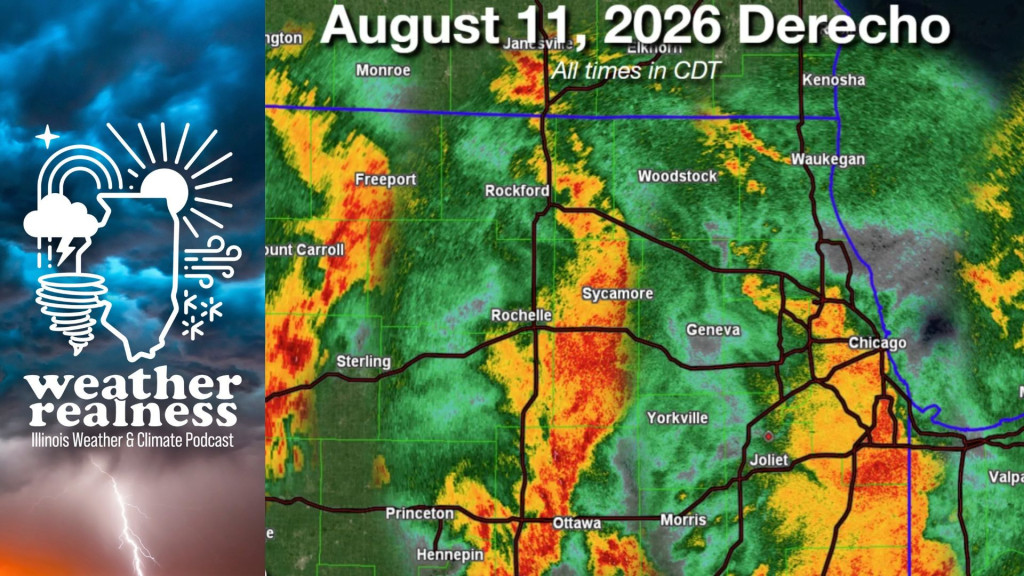
Transcript: What makes derechos so dangerous?
Weather Realness
What makes derechos so dangerous?
Read the full story at https://will.illinois.edu/weatherrealness/what-makes-derechos-so-dangerous.
Transcript
// This is a machine generated transcript. Please report any transcription errors to will-help@illinois.edu.

[00:00:00]
Speaker 0: The weather and climate often cause concern and curiosity, but understanding the facts behind the phenomena can be a challenge. We're here to help. From the University of Illinois Urbana-Champaign and Illinois Public Media, welcome to Weather Realness, a weekly podcast about the skies above Illinois and the world.

[00:00:31]
Eddie Wolf: I'm your host, Eddie Wolf, graduate research assistant in the Department of Climate, Meteorology and Atmospheric Sciences at the University of Illinois. On Aug. 11, a powerful derecho produced widespread 70 to 100-plus mph straight-line winds across northeastern Illinois and northern Indiana.

[00:00:50]
Speaker 2: The opening of a severe thunderstorm, Demetrius, in terms of wind gusts is 58. 58. That's 58, and we, we dwarf, dwarf that

[00:00:57]
Speaker 3: just. Boom, downburst. Several barns destroyed and the debris, you know, spans half a mile or more into the field down to the next highway over.

[00:01:10]
Eddie Wolf: This results in wind damage across the south and southwest Chicago suburbs, as well as northwest Indiana, with hundreds of thousands of power outages. Additionally, the National Weather Service has confirmed that 8 tornadoes occurred in the Chicagoland area. Joining us to talk about how the [derecho] became so destructive is Jeff Frame, professor in the Department of Climate, Meteorology and Atmospheric Sciences at the University of Illinois. Thanks for joining us, Jeff.

[00:01:34]
Jeff Frame: Thanks for having me, and as always, it's great to be back.

[00:01:38]
Eddie Wolf: So I want to start off just with some terminology here. I think, you know, derecho is a word that folks have probably heard before, but maybe don't understand exactly what this is. So can you talk a little bit about what a derecho is and what differentiates it from your average line of severe thunderstorms?

[00:01:51]
Jeff Frame: Yeah, [a] derecho is a line of thunderstorms, but what differentiates it is it produces a lot more widespread wind damage over swaths measuring hundreds of miles in both directions. And it also produces a lot of intense wind gusts as well, and I'll get into that. There are actually specific criteria used to define a derecho, and these were just revised last year in 2025. So the wind swath has to be 250 miles long. Now they shortened that — it used to be 400 — but that means from when the severe wind gusts started as the system progressed, that has to be 250 miles, basically in the direction the line is moving. The line has to be at least 60 miles long, and the system must last for over 3 hours. There can be no big gaps in wind reports either in time or in space. So if you have something really intense and then it weakens for a couple hours and then restrengthens, it won't be a derecho. Additionally, there must be 3 reports of wind gusts 75 mph or greater separated by 80 miles. So we can't just have one area, for example, where the wind damage was really bad, but we have to have bad wind damage scattered over a lot of that area. And then finally, the last criteria they added is that the system must move faster than the environmental winds. So those — in other words, the strong winds must be generated by the line of thunderstorms. Sometimes you see this — a lot of times more in the wintertime or in the cold season, right — where you have a lot of wind in the atmosphere. And if a system is just able to bring down those winds, say from 0.5 mile or 1 mile above the surface, and move at those real fast speeds, that will no longer be classified as a derecho.

[00:03:44]
Eddie Wolf: It's a little bit more sort of terminology here. Oftentimes we'll refer to these as straight-line wind events. Can you talk a little bit about why we call them that? Why do we say straight-line winds, straight versus what, and what kind of makes them different compared to something like a tornado?

[00:03:57]
Jeff Frame: Right, good question. So straight-line winds, as the terminology might suggest, in the line, the winds are really moving in a straight line. They're all kind of blowing in one direction — oftentimes out of the west with a system like this, because our weather does tend to move from west to east. And the term derecho actually means "straight ahead" in Spanish. A lot of you [were] probably able to figure out that that is a Spanish term there that's been adopted into English, whereas winds in a tornado rotate, right? We know tornadoes spin, they rotate. And most tornadoes are relatively small. The average size of a tornado is 100 meters across, or that's about 100 yards, a football field, right? [Going on], but these derechos produce these winds blowing all in one direction over a much larger scale. Now, derechos — the most extreme derechos — can produce winds near and even exceeding 100 mph, which would rate it EF2 on the Fujita tornado damage scale. So powerful derechos can produce winds similar to weak or even moderate tornadoes. For example, the derecho that occurred Aug. 10, 2020, came across Iowa and eventually into northern and central Illinois, [and] produced widespread wind reports of 130 mph. Some of these were measured around Cedar Rapids, Iowa. There's even a video on YouTube after the event of somebody driving around a neighborhood there, and basically every house has a downed tree, at least one, somewhere on the property, and I show that in class and it's just pretty amazing. It's almost like, you know, a weak tornado 10 miles wide came across the city. And of course, with all the power outages that that produces, that can cause a lot of damage even after the fact, you know, with spoiled food and so forth.

[00:05:57]
Eddie Wolf: Yeah, like you mentioned there, these can cause really widespread, pretty severe damage, similar to a tornado, and we've seen that with this most recent [derecho] as well up in the northern part of the state and northern part of Indiana as well. So talking a little bit more now about this August [derecho] that we just had, what were the conditions that actually sort of created this event? Can you talk a little bit about the weather setup

[00:06:16]
Jeff Frame: we

[00:06:16]
Eddie Wolf: had?

[00:06:17]
Jeff Frame: So compared to a traditional thunderstorm environment, derecho environments tend to exhibit greater amounts of instability, or what we like to call storm fuel on this program. And so that's warm, moist air near the surface, and then as we go above the surface, we see that the temperature decreases very rapidly with height. And if you looked at the sounding launched out of Lincoln, Illinois, on the morning of Aug. 11, basically the temperature was cooling with height as rapidly as the laws of physics allow it to, around 2 or 3 miles up into the atmosphere. And so that allows a lot more instability to develop than would otherwise be the case if the temperature didn't cool nearly as rapidly with height. And then we also need at least moderate wind shear — that is, a change in wind speed or wind direction with height, especially down near the surface. And what that does is it allows the cold air that rushes out of the storm — right, those winds are actually blowing cold air — those strong straight-line winds are actually blowing cold air out of the storm. We call that outflow because it flows out of the storm, and it actually restrains that a little bit and doesn't allow it to run way out in front of the system. Because if it does that, you now have a thunderstorm surrounded by its own cold air, and thunderstorms don't like to eat cold air, right? It's like, you know, trying to feed a baby vegetables, right? That's just not going to work very well. And so if we don't have that wind shear, what happens is the storm — we say it gusts out — and this cold air surges away from the storm, and now it's sitting in a pool of its own cold air, and, well, it has no more storm fuel, so it tends to weaken pretty rapidly as that happens. So because that didn't happen, that caused the storm to maintain its intensity as it moved across the Midwest and actually reached all the way into Cincinnati and northern Kentucky after it moved through nearly the whole state of Indiana.

[00:08:20]
Eddie Wolf: So we were talking earlier about the differences between tornadic winds and straight-line winds, but of course this event also did produce a few tornadoes up near the Chicago area. Can you talk about how a system like this is able to also produce these tornadic events?

[00:08:33]
Jeff Frame: Yeah, sure. So yeah, lines of storms — you know, you see them on radar — the No. 1 threat with them is wind damage. It tends to be a lot more widespread than tornadoes, but depending on the environment again, particularly if we have that low-level wind shear, that low-level change in wind speed and wind direction with height, some of that horizontal rotation due to the wind shear can be tilted and then stretched by the storm's updraft into a tornado. Sometimes we can have that outflow coming out a little bit and it can cause rotation on the flanks of that, and that vertical rotation can also be stretched. But these tornadoes that are produced by lines of storms like this — they can be a real pain, very difficult to warn for, if you're a forecaster at the National Weather Service, because unlike a supercell, right, which is about the size of a county or a little smaller than that — you got your hook echo, that's right where the tornado is going to form in that supercell thunderstorm — whereas with these lines of storms, it's pretty much anywhere along that leading edge, which again could be 50, 60, 100 miles long. And these areas of rotation can spin up very, very quickly and also dissipate very, very quickly. So these tornadoes tend to be a little shorter-lived and a little weaker on average than your supercell tornadoes that we saw, for example, back on June 11 up in north-central Illinois. June 17, Charleston and Effingham were hit by supercell tornadoes. But these here, they tend to be weaker, but again, not always. There have been some of these tornadoes out of lines of storms that have been rated EF3 and even one I can recall in South Carolina in 2020 that was rated EF4.

[00:10:21]
Eddie Wolf: If you're just joining us, this is Weather Realness, the podcast about weather and climate from Illinois Public Media and the University of Illinois Urbana-Champaign. I'm Eddie Wolf, graduate research assistant in the Department of Climate, Meteorology and Atmospheric Sciences at the University of Illinois. We're talking with Jeff Frame, professor in the Department of Climate, Meteorology and Atmospheric Sciences at the University of Illinois. How often do these actually happen in Illinois? Can you talk a little bit more about that?

[00:10:45]
Jeff Frame: Yeah, so if you look at the climatology, which is a bit difficult — and I'll go into that a little bit later — most places in Illinois, not the entire state, but most places in Illinois, see about one derecho every year. Now, Illinois, of course, is very large, especially from north to south, so the same derecho that might affect Chicago and the suburbs in the northern part of the state might not — probably won't — affect Carbondale and, you know, areas well downstate, closer to the Ohio River. And if you look at this year actually, some of the same areas that were hit on Aug. 11 — so Chicago and some of the suburbs, northwest Indiana, parts of southern Wisconsin into Michigan — were also hit with the derecho on June 10, the day before some of those same areas experienced pretty devastating tornadoes. So some of those areas have seen two derechos this year. I know it's been a very stormy summer as well here in Champaign-Urbana, but as far as I know, those are the only two events widespread enough and intense enough to have been classified as a derecho this year in Illinois.

[00:12:00]
Eddie Wolf: So all these events we've been talking about for the most part have occurred in June, July, August. What is it about these sort of summer months that makes these events really common, right?

[00:12:09]
Jeff Frame: So I mentioned what separates a derecho environment from a more ordinary thunderstorm environment, or just a line of windy storms, is that more instability. And so again, the big ingredient in that — one of the big ingredients in that — is warm, moist air near the surface. Well, what times of year is the air hottest and most humid? You know, it's late spring into the summer, so May kind of through August is your hot spot of the year for derechos. Now they can occur any time of year — March and April — but again with the revised criteria, your cold-season derechos, I think, are going to be quite a bit less common going forward here, just because of the change in definition there.

[00:12:57]
Eddie Wolf: And of course these are, you know, these really large, impactful events, but there are forecasting challenges when it comes to these as well. Earlier you mentioned preceding thunderstorms in Indiana that caused the storm to eventually weaken. What are the challenges, especially with some of the preceding day's weather, that can make these hard to predict sometimes?

[00:13:12]
Jeff Frame: Now, derechos — like hurricanes — are kind of able to be resolved by a lot of our numerical forecast models. They work completely differently than hurricanes. We don't want to call them land hurricanes or a [land cyclone] — that again, some of your [forecasters] tend to do. They work completely differently from those tropical cyclones. But our models can usually resolve them. But unlike hurricanes, right, where if we get a hurricane out there, you know, we can sense what the ocean conditions and the atmospheric conditions are like out ahead of it — we can, you know, predict whether or not it'll stay over water or over land — so hurricanes are a little more predictable than derechos. Whereas if we look at tornadoes, no matter what forecast model we look at, it is too [coarse in] resolution — that is, the grid points where the model solves all these complicated atmospheric equations are just too far apart to resolve a tornado. So our highest-resolution model, 3 kilometers — there have been experimental ones run at 1 kilometer that still can't see a tornado. Again, average width here 100 meters, 100 yards. And so we can't tell when a tornado might happen looking at these things. But what we can see to predict tornadoes is a signal of a rotating thunderstorm in the model, and what we can sense is the environment around the storms. Again, do we have instability? Do we have the wind shear, and is the wind shear distributed correctly? I don't want to get too technical on this, but not all wind shear is favorable for tornadoes. We look at this on a graph called a hodograph, and you know, there's a hodograph [configuration] favorable for tornadoes. We can launch weather balloons obviously and do that too. Predicting derechos kind of falls somewhere in the spectrum between tropical cyclones like hurricanes and tornadoes, where it's like, OK, you know, tornado chances there, but we cannot tell you hours in advance who's going to be hit.

[00:15:24]
Eddie Wolf: If you're just joining us, this is Weather Realness, the podcast about weather and climate from Illinois Public Media and the University of Illinois Urbana-Champaign. I'm Eddie Wolf, graduate research assistant in the Department of Climate, Meteorology and Atmospheric Sciences at the University of Illinois. We're talking with Jeff Frame, professor in the Department of Climate, Meteorology and Atmospheric Sciences at the University of Illinois. Climate change, of course, is always a big question with any kind of major weather event. Of course, attributing convective events like this — these sort of smaller-scale events — to climate change is difficult. Is there any sense of how these storms might change in a warming climate?

[00:15:58]
Jeff Frame: So yeah, you mentioned that, and climate change doesn't cause derechos, just like it doesn't cause hurricanes or cause anything else. What it does is it makes certain things more or less likely. So again, thinking about it in terms of probability. All of our climate models that we run — and again they go out decades — but what these models don't do is they don't say, OK, on June 12, 2035, there's going to be a derecho in Illinois or Missouri or New England or wherever. We don't do that. What we do is we look at how the long-term average climate changes, and what all these models are telling us is that with continued greenhouse gas emissions, summers will get warmer and more humid, as well as especially more in the spring months here in Illinois. The corn actually has dampened that summer warming a little bit, believe it or not. And so more warmth and more humidity yields more instability. So we think that unlike tornadoes — where we think the total number stays about the same — we think the [derechos] will actually get a little bit more common here as we go in the next few to several decades toward the end of the century.

Now looking at the observed record, this gets very difficult, because I mentioned the term derecho didn't really come into public parlance until 2012. And so you can actually — I actually went over to the Wikipedia page and looked at their list of [derechos] yesterday. And the first recorded one was in 1877, and then you don't have another one listed until 1965. We did not go almost 90 years without a derecho anywhere in the United States. That's completely not going to happen. So we have 1965, 1969, a couple in the 1970s, a couple in 1980, and then nothing until the 1990s. And you might say, well, what's going on here? Well, a couple things. No. 1, just like tornado reports are plagued by this inflation problem — due to mainly, well, some is growing population, but the big thing is changes in reporting practices where everybody now has a computer with a camera in it that is connected to the internet in their pocket and they can very easily report wind damage. 20 years ago in the 2000s, people did not have that kind of connectivity. And so that's one issue. What we don't have is this archive of wind reports online. I think the Storm Prediction Center archive of severe weather reports begins in like 2003. And then you say, well, we need these big lines of storms — can we look at radar data? Well, we have radar data only archived to about the mid-1990s when our current radar system was established. So that's why, you know, we don't really see an observed increase in [derechos], or if it is, it's just drowned out by all these other factors.

[00:19:14]
Eddie Wolf: Yeah, I think it's really easy to forget just how new a lot of the things we have in this field are — like you mentioned, things like radar, really 1950s, 1970s when we started getting these sort of [quasi-national] networks of radars coming in — a lot of this is just really new still. So I want to wrap up here on the topic of safety and what the public can do in the face of these events. So obviously the National Weather Service doesn't issue derecho warnings. They issue severe thunderstorm warnings when [derechos] are approaching. Can you talk a little bit about how maybe they communicate this enhanced hazard when there are these really severe wind events happening?

[00:19:47]
Jeff Frame: Right. So severe thunderstorm warnings do encompass kind of a wide variety of hazards. For example, last week a severe thunderstorm warning was issued, I think south of Danville, southeast of Champaign-Urbana, and I think there was one tree damage report collected from that event. And I mean, is that going to be a strong storm making, you know, a lot of 50 mph winds, maybe some small hail? Yeah, heavy rain, yes, lightning, yes — all thunderstorms are dangerous because of lightning, so we don't issue warnings for lightning. So they encompass, you know, events like that all the way up to, you know, events like this derecho, or even derechos that I mentioned in the past that have been more intense than this. So it covers really a wide gamut of hazards. Your basic severe thunderstorm warning will be for 60 mph wind gusts and/or quarter-sized hail, and then as we go up the scale — both to larger hail and stronger winds — we do have tags that the weather service can attach to these warnings, for example, destructive or catastrophic tags. So if we're talking about a storm with 80 mph wind gusts, even if it's not a tornado warning, in some communities — and it's up to the emergency management of the county or of the city — whether or not the sirens go off, and also, again, depending on the severity of that severe thunderstorm warning, it's possible that if you have your phone configured right — and you should to accept Wireless Emergency Alerts, or WEA for short — it'll trigger an alert on your phone for that.

And especially folks who are organizing and running outdoor events: We don't want to think, "Oh, it's just a severe thunderstorm warning," because even 60 mph wind gusts to outdoor structures like tents and things like that can cause significant damage that can lead to significant injury and loss of life. The best example of this tragically occurred in August of 2011 at the Indiana State Fair, I believe it's near Indianapolis, where we had a line of storms warned for 60 mph winds come through that area. And you know, somebody either did not evacuate or shut things down, or they were too slow in doing it, or thought, "Oh, it's only a severe thunderstorm warning." The wind caused the stage to collapse. You can look up the video on YouTube, but I want to warn you it is pretty jarring to see this large structure coming down on people, and you had several deaths — [and] dozens of [injuries] from that.

So [when a] severe thunderstorm warning is issued again — best course [of action]: get indoors into a sturdy structure, lowest floor, away from windows, because these strong winds can, in your extreme cases, remove roofs from structures. They can, of course, cause a tree to come down on your house. And again, the lower you are in the house, the less likely you are to be impacted by that. The No. 1 danger here is the lightning, because it can really come from anywhere in the storm. It moves so quickly — 100,000 miles an hour from the cloud down to the ground — that you cannot get out of its way. And we even had an incident — we were out in eastern Kansas one day last June, and we're actually pretty far away from the storm, but we did have that high-level anvil cloud above us. And you know, a couple of the ladies' hair started to stand up on end because of the electric field, and we jumped right back in the van. Now fortunately we didn't have far to go, but certainly, you know, you see something like that, you just got to get inside anything relatively safely. And vehicles — cars, things like that — are adequate protection from lightning, as long as you have the windows rolled up. And the reason is it's the metal frame that conducts the electricity around the outside of the car. It's not the tires or anything like that. You know, [a] convertible, probably a no-no there. And then certainly you don't want to be touching anything plugged into any of the outlets or anything metal in the vehicle.

[00:24:07]
Eddie Wolf: And we do also just want to mention — earlier you mentioned sirens occasionally will go off for these destructive damage tags, and Champaign County, for our listeners here, is one of the counties that will sound them in those cases. So potentially in these really high-intensity wind events, you will get that kind of warning as well. But of course, as we always say, listen to your phone as well, make sure you have those warnings set up to receive. Well, thank you again, Jeff, for joining us today and for teaching us all about derechos.

[00:24:31]
Jeff Frame: All right, always a pleasure, Eddie, and all of you keep paying attention to the weather and always stay weather aware.

[00:24:39]
Eddie Wolf: We've been talking with Jeff Frame, professor in the Department of Climate, Meteorology and Atmospheric Sciences at the University of Illinois. I'm Eddie Wolf, graduate research assistant in the Department of Climate, Meteorology and Atmospheric Sciences at the University of Illinois. Thank you for joining us on Weather Realness. Do you have a weather or climate question you want us to answer? Leave us a voicemail at 217-333-2141 or email [weatherrealness@illinois.edu].

---

**Flags for Human Review:**

- **[00:00:50] Speaker 2 / [00:00:57] Speaker 3** — Two unidentified speakers appear in a brief segment that appears to be audio clips (field recordings or testimonials). Their identities are unknown. The phrase "The opening of a severe thunderstorm, Demetrius" in Speaker 2's segment is unclear — "Demetrius" may be a name, a misheard term, or an artifact of transcription. Human review is recommended.
- **[00:03:57]** — "Goaina" in the original transcript is unclear and likely a transcription error. The passage was rendered as "[Going on]" based on context, but human review is recommended to confirm the intended word or phrase.
- **[00:13:12]** — "landoon" in the original transcript is unclear. Rendered as "[land cyclone]" based on context, but human review is recommended. Similarly, "hypecasters" was rendered as "[forecasters]" — if the speaker intended "hypecasters" as a colloquial or pejorative term, the original should be preserved.
- **[00:13:12]** — "two co resolution" was interpreted as "too [coarse in] resolution" based on context. Human review recommended.
- **[00:13:12]** — "forecast photograph" was interpreted as "hodograph [configuration]" based on context. Human review recommended.
- **[00:19:14]** — "pseudoational" was interpreted as "[quasi-national]" based on context. Human review recommended.
- **[00:23:47]** — "several deaths in dozens of fatalities" is ambiguous — the original audio may have said "several deaths and dozens of injuries" or a similar phrasing. The rendered text reflects a likely intended meaning, but human review is recommended to verify against the audio.
- **[00:24:39]** — The email address "weatherreness@illinois.edu" in the original transcript appears to be a transcription error. Rendered as "[weatherrealness@illinois.edu]" based on context, but human review is recommended to confirm the correct address before publication.
Transcript Assistance
Illinois Public Media may use AI assistance for transcript generation and/or formatting. Transcripts that have not yet been reviewed for accuracy will be labeled.
To report a transcription error, or to request transcription of archival material, please contact will-help@illinois.edu.