
Great Lakes Basin Railroad Factors In Geography, But Environmental Questions Remain
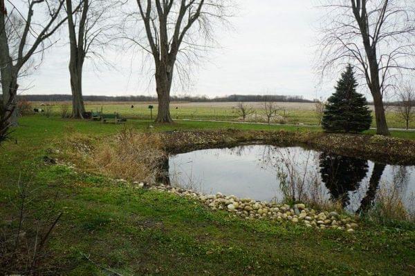
A pond behind Kathi and Jerry Jurkowski's home in Rockton is for more than aesthetics: It helps drainage in an area with a high water table. Opponents of the GLBR say the area in northern Illinois is too swampy to support the necessary infrastructure. Susan Stephens/WNIJ
AMC's Hell on Wheels is a fictionalized version of the construction of the First Transcontinental Railroad across the Wild West in the 1860s.
The show draws much of its drama from a greedy tycoon who encourages workers to weave and wind tracks every which way to maximize profit—with little regard for the land.
Upon seeing a blueprint, self-proclaimed "villain" Thomas Durant laments, "Why have you made my road so straight?"
That is not so easy to get away with these days.
What type of geography is along the proposed route?
Mike Blaszak is a lawyer representing Great Lakes Basin Transportation, Inc. He says the plan is to avoid "hairpin" turns because a straight path allows the trains to reach higher speeds. Blaszak says great care has been taken to get the lay of the land.
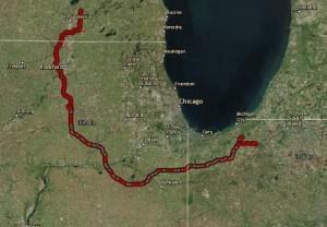
This is a map of the current route proposal for the Great Lakes Basin Railroad.
"If somebody brought up that there was a feature that exists in the land that we weren't familiar with ... for example, I can think of one that was an old cemetery," Blaszak said. "It was an old cemetery that didn't do any marketing, but we found that there was one close to the route. We were able to adjust the route for that. We looked at river crossings. We are going to cross four major rivers. There will be four major bridges on the route. We are trying to select the river crossings that are the shortest and have the least environmental impact and make the most sense with respect to building the railroad."
How does the federal government come into this conversation?
The level of environmental scrutiny slows the process down considerably. Blaszak explains that there has to be an Environmental Impact Statement in order for the federal government to take any action on a requested permit.
Great Lakes Basin Transportation, Inc. is requesting a pause in that process, but Blaszak says he doesn't expect that will delay the overall timeline.
He says federal Surface Transportation Board members also have to approve construction in a separate process based on the law in which the potential transportation and financial impact are presented.
And when the Environmental Impact Statement is finalized, the board can act on the application and "approve" or "approve with conditions," or "reject" it. Blaszak says that could take another two years, but it is up to the Surface Transportation Board to create the precise timeline.
"When the STB acts, if it approves the railroad, then we would begin land acquisition and construction," Blaszak said.
What is the current impact of trains on the environment?
Mike Phillips, a geologist with Illinois Valley Community College in Oglesby, says a railroad of this scale can be a trade-off for the region.
"We already have a lot of trains going through the area. They go into Chicago, they get stalled in Chicago for traffic reasons," Phillips says. "While all the trains are sitting there, they are dripping on the railroad tracks a little bit, but more significantly, they're putting emissions into the air. That is unnecessary if they are just sitting there. One of the positives of this rail line is to keep the trains moving around Chicago, [which] means you are getting more distance per unit of pollution that you are putting out."
Geologically speaking, would the concern for the proposed route be for worst-case scenario instead of day-to-day issues?
Phillips says, "Just like if you are next to a highway, things drip off vehicles and things are going to drip off train engines. It is relatively small amounts. Things might fall out of railcars if they don't have perfect containment. Things drip out. Over time, that can be a concern. The other thing we look at is if there is a train accident. If a railcar -- or a set of railcars -- carrying oil, for example, have an accident, this certainly happens occasionally, what are their plans to deal with that?"
What other questions come to your mind?
"One of the kind of interesting things that I noticed when I looked at the pathway is, if you are familiar with northern Illinois history, there were a lot more railroad tracks in the past than we have today.
"In some places, you can see the pathway of this railroad coming close to where there used to be railroad tracks. In some ways, we are kind of building out what we tore down in the past. One notable exception to that is, if you look at where those old railroads went, they typically went through towns.
"They did that because they were part of our transportation system and also because the towns grew up around the railroads. This railroad tends to go around the towns, so they are trying to avoid major population centers. That feeds into what they want to do with the tracks.
"One of the questions that I have is, as they are going through here, what kind of care are they taking to avoid sensitive areas, environmentally speaking? One example would be wetlands. If you look at the maps, they are mapping out all the local wetlands. They are either going to have to avoid those or they will have to mitigate, which usually means creating a new wetland elsewhere to take the place of the one you damaged.
"The other thing that I am not aware of, but they are probably doing and should look at, is where are the wells for local towns? Are they making an effort to kind of avoid the area that collects water for those wells? We would call that the recharge area. You could determine a sensitive area around a public water supply well and then say, 'We really probably shouldn't have the railroad track going through that sensitive area.'"
A map of trails, parks, rivers and streams.
How can stakeholders have a better idea of what's along the path?
One group keeping an eye on the land and water is the Rockford Metropolitan Agency for Planning.
That organization created maps which show an interconnected system of trails, parks and preserves, rivers, streams and lakes for Winnebago and Boone counties.
Executive Director Mike Dunn says people who live in communities along the proposed route can cross-check the proposed route with what they have identified along the line.
"Whether it is forest preserve, whether it's private farmland, whether it's watersheds, whether it's how this thing might pass a creek or a river, whether it's impact on homes — noise contours, sound contours, vibrations, how it is going to impact who might not have a home set on a farm but just along a county highway-- all those parties need to be considered."
Which means there are expected to be a lot more people at the table than when the Wild West was built.
- Here's part one of Down the Line, What is the Great Lakes Basin Railroad? WNIJ's Jenna Dooley and Susan Stephens discuss the project and its plans.
- In part three on Wednesday, we'll take a closer look at the land acquisition process for the GLBR project.
