Here’s What You Need To Know About Hurricane Irma

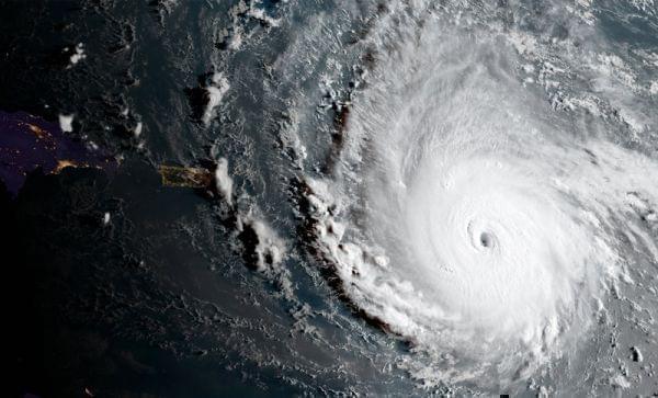
The most powerful Atlantic Ocean hurricane in National Hurricane Center records has roared into the Caribbean and was on a path to hit Florida this weekend or early next week. As of Wednesday, Irma had maximum sustained winds of 185 mph. NOAA/AP
Irma has quickly become one of the most powerful Atlantic Ocean hurricanes ever recorded, with wind speeds of 185 miles per hour. As this monster churns through the Caribbean and heads toward Florida, here's the lowdown.
How dangerous is it?
Irma is a Category 5 storm, which means sustained winds of greater than 157 mph. Winds that strong can destroy framed homes and many masonry structures that aren't reinforced. Forecasters predict that Irma's damage may be more tornado-like than the devastation wreaked by more typical hurricanes. Normally, the worst damage from a hurricane comes in the "eyewall" area to the front right of the eye. But Irma is so big and powerful that the damage zone could be extensive regardless of exactly where its center tracks.
How does Irma compare to Harvey?
Harvey caused trouble by basically parking in one place and dropping mind-boggling, historic amounts of rain. Irma, by contrast, is a whirling dervish that will sweep through islands such as Puerto Rico, Vieques, Culebra and the British and U.S. Virgin Islands. Unlike Harvey, Irma's damage should come primarily from storm surge and the violent winds.
What could Irma do to Florida?
The National Hurricane Center says that the chance of direct impacts to Florida continues to increase, but "it is too soon to specify the timing and magnitude of these impacts." Florida officials have already announced mandatory evacuation orders for the Florida Keys, and more are expected for Miami-Dade County, in the coastal areas that could see storm surges.
Is it unusual to have two strong storms back to back?
Harvey was the most powerful storm to hit the mainland U.S. in over a decade, and now Irma is hot on its heels. But this isn't the first time two impressive storms have hit in rapid succession. In 1954, Carol and Edna menaced the East Coast within two weeks of each other, and were soon followed by Hazel. In 1955, Connie and Diane "struck the North Carolina coast only five days apart," according to the National Hurricane Center. But hurricanes draw their strength from the warmth of water below, and climate scientists point out that global climate change is increasing ocean temperatures, likely producing more powerful storms.
Links
- Local Blood And Money Donations Needed For Hurricane Harvey Relief
- Hurricane Harvey Continues Path Through Texas
- Harvey’s Devastation Hits Home As Residents Return To Flooded Neighborhoods
- Harvey Hits Home To Lovie Smith
- PHOTOS: Houston Flood Caused By Harvey Sends Residents Scrambling For Safety
- Explosions Reported At Flooded Arkema Chemical Plant In Crosby, Texas
- At Least One Person Killed As ‘Catastrophic’ Floods Inundate Houston

