
Transcript: What’s behind Illinois’ record year for tornadoes?
Transcript: What’s behind Illinois’ record year for tornadoes?
The 21st Show
What’s behind Illinois’ record year for tornadoes?
Read the full story at https://will.illinois.edu/21stshow/whats-behind-illinois-record-year-for-tornadoes.
Transcript
// This is a machine generated transcript. Please report any transcription errors to will-help@illinois.edu.
[00:00:00]
Brian Mackey: From Illinois Public Media, this is the 21st show. I'm Brian Mackey. Over the past couple of weeks, Illinoisans have had to seek shelter through multiple rounds of intense storms and many, many tornadoes. Take June 11th. Northern and central Illinois were hit by 20 tornadoes, with two of them coming with a destructive rating of EF3 — that's on the Enhanced Fujita scale. Then last Wednesday, the National Weather Service reports 7 tornadoes passed through central Illinois, including another EF3 tornado that hit Effingham and an EF2 in Charleston and Mato. Here's Charleston resident Marilyn Wendell speaking to Illinois Public Media with her reaction.
[00:00:47]
Marilyn Wendell: We just finished putting that whole roof on the porch there, and now look at. Ah.
[00:00:56]
Brian Mackey: And the hits keep on coming. This morning we learned of tornadoes passing through southern Illinois. KFVS-TV in Cape Girardeau, Missouri says at least 2 deaths and 5 injuries are linked to the tornadoes in that area. A National Weather Service survey and damage rating are still pending there.
Given all of this, tornadoes and severe weather are the subject of our program today. How did all these storms play out? How are communities cleaning up in the aftermath, and what major problems need to be addressed after these storms? Then, later in the hour, we'll take a step back and talk through the bigger picture, climate change, and what this increasing pace of severe weather means for the future of life in Illinois.
But first, the damage. I'm joined now by Abigail Bottar, agriculture and environmental reporter for our home station, Illinois Public Media. Abigail went to Effingham to talk with people about what they experienced and survey the damage there. Abigail, welcome back to the 21st show. Good morning. Also joining us, Sam Rink, a reporter, host, and associate producer here at Illinois Public Media. Sam went to Charleston to cover the aftermath of the storms there. Sam, welcome back to you as well.
[00:02:07]
Sam Rink: Good morning.
[00:02:08]
Brian Mackey: And Steve Nesbitt is professor and head of the Department of Climate, Meteorology and Atmospheric Sciences at the University of Illinois Urbana-Champaign. Also the host of our sister podcast from IPM, Weather Realness. Steve, welcome back to you.
[00:02:23]
Steve Nesbitt: Good to be with you.
[00:02:24]
Brian Mackey: Listeners, you can join us throughout the hour today. If you experienced the storm — I said the storm, these many storms — we'd love to hear about what it was like for you. 800-222-9455. How are you reacting to the fact that Illinois is now seeing a lot more tornadoes than we used to? 800-222-9455 is the number. 800-222-9455.
All right, Steve Nesbitt, I'm going to start with you. What do we know about the storms beyond what I just said in the introduction there, specifically that last Wednesday that passed through central Illinois.
[00:03:00]
Steve Nesbitt: Yeah, this was an extraordinary event. Set a lot of records, including some measurements that we were able to take here on campus with a weather balloon, and I'll talk a little bit about that in a minute. But it was an extraordinary event, obviously a tricky forecast, and for those of you that were watching the forecast that day, you probably noticed that most of central Illinois was sort of under the gun according to the outlooks from the Storm Prediction Center that morning. But the actual threat shifted quite a bit south and the main axis of severe weather was actually south of Champaign-Urbana, and areas like Bloomington-Normal and other areas north of there were not in the area when it came to push comes to shove. So that was a challenging forecast in the morning.
It was one of those typical events here in central Illinois where there's a warm front kind of moving in from the south, and that warm front really was the delimiter between where you were in a risk area to the south and sort of just in a gentle rain, cool morning-type situation to the north. And along that warm front there was an extensive area of rain, and you probably noticed if you were outside at lunchtime it's like, wow, it's still cool, it's still raining — kind of held on for a long time, which kept the threat down here in Champaign-Urbana. But if you were further south, that warm, moist air from the Gulf really started to move in, and that's where we saw the storms really start to form, and a lot of wind shear in the atmosphere with that case.
We launched a weather balloon around 3 o'clock here on campus and it was blowing at over 65 miles an hour, only about 2,000 feet above the ground. And that wind turned clockwise with height with that typical sort of hook that we see a lot of times in the low-level wind shear that causes thunderstorm updrafts to rotate. And there was no surprise that right after that we saw explosive development of tornadic supercells just south of our area.
[00:04:51]
Brian Mackey: For those of us who are not your students in this, what is 65 miles an hour at 2,000 feet? Like, how — oh my gosh, that's a crazy thing, you know — put that in context for us.
[00:05:00]
Steve Nesbitt: Yeah, for June around here that's unheard of. I mean, this is probably about 20 or 30 miles an hour over the threshold for a tornado. Really strong low-level winds, and that turning and that strengthening of wind with height is really what provides that energy for updrafts to rotate and provide the environment for a tornado to develop.
[00:05:20]
Brian Mackey: Well, and tornadoes did indeed develop elsewhere in Illinois. And Abigail Bottar, I'm gonna bring you in now because you did, as I mentioned, go to Effingham, surveyed the damage, talked to people there. What did you see?
[00:05:31]
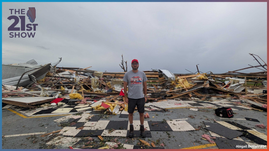
Abigail Bottar: Driving in, just a lot of downed trees, a lot of downed power lines. And then I stopped — we had heard that there was some significant damage to a car museum — and so I stopped there, and that was just the most destruction I had seen. That had completely flattened this museum that was holding, like, antique Corvettes and all this one-of-a-kind memorabilia. It was completely flattened. They had this big warehouse that was still standing, but the roof was gone and it was kind of like tattered. I don't know, I don't know how to describe it. It was truly — I had not seen anything like that with my, my eye, in person before.
Luckily there were no injuries that we had heard of, but it was just truly like insane to be standing where a building was less than 24 hours ago and it was just — everything was gone.
[00:06:27]
Brian Mackey: Yeah, after the show, we'll have on our web post a photo you took there of the — I believe the president and CEO Michael Jaeger of this business, MidAmerica Motorworks. It's quite striking. We also have some tape that you sent us. Let's listen to him again. This is Michael Jaeger, president and CEO of [MidAmerica Motorworks], talking about how he reacted after the storm.
[00:06:49]
Michael Jaeger: I think my building is gone. And so I couldn't even get out of my neighborhood. There's trees and just all kinds of stuff down. So as soon as I could get out here, you know, my insurance agent was already on the phone with me. He's like, I'm gonna need you out there, you know, we'll see what's going on. And we get out here and, uh, yeah, it was quite literally gone.
[00:07:08]
Brian Mackey: What did he — yeah —
[00:07:09]
Abigail Bottar: Go ahead. Well, I think it was crazy because he and his wife — I was able to speak with both of them. They were both there trying to grab anything from the rubble that they could that they thought they could salvage. They were at home Wednesday night and saw the tornado touch down from their house. Luckily it just went past their development, so none of the houses had a lot of damage. Their house was fine, but they watched the tornado touch the ground, ran into the basement. The power went out. As the power came back on, they started getting texts of just this completely damaged building, and they were like, what are we looking at? And then they realized it was their business — that was, so they, they just, it was, you know, beyond recognition, the damage. And so yeah, when he was finally able to, you know, get out of his house and see it, it was just crazy. But to see the tornado touch down, I just can't imagine watching that from your front yard.
[00:08:06]
Brian Mackey: Yeah, wow. All right, Sam Rink, I'm gonna bring you into the conversation now. I mentioned you went to Charleston to survey damage there. How do things look from your point of view?
[00:08:16]
Sam Rink: Yeah, it was, as I was driving into town, you know, I was sort of seeing a similar thing that Abigail was seeing, I think — lots of downed trees and power lines. But the biggest thing that I noticed was the sound. It was all generators running and chainsaws that whole morning and throughout the afternoon because Charleston was without power. At some point during the storm, when all those power lines started snapping, they lost power, and throughout the entire day that Thursday following the storms, they still didn't have power. And driving around town, it made sense why — there was, you know, there was an entire street where every single utility pole was, you know, fully snapped off a couple of feet above the base. And, you know, trees — some of the worst damage that I saw was, you know, trees being uprooted, falling just straight into buildings, crushing roofs, that kind of thing.
I didn't see any buildings that were completely destroyed, at least where I was in town. But I was told by the mayor that some of the worst damage was concentrated in the northern and western parts of Charleston, and then sort of going up towards that area of town. But yeah, they started on cleanup pretty much right away, and that was really the biggest thing that I noticed is how, you know, people were out in the streets and out in each other's yards — people had called their friends and family to come over — and, you know, people, they didn't waste any time before they started, you know, trying to take care of the damage and clear up the roads.
[00:09:43]
Brian Mackey: Yeah, no, that's an interesting point. I've covered a storm in Taylorville, Illinois some years ago and I was struck that even the next morning there are already bulldozers and backhoes and, you know, everyday people out there with chainsaws and things like that.
All right, let me remind listeners this is the 21st show. We're talking about the recent storms, tornadoes that have passed through Illinois in recent weeks. And for the first part of the program today, we're talking about what damage has been wrought by these storms and what it was like going through them in real time. We're talking with Sam Rink, who's a colleague here at Illinois Public Media — reporter, host, associate producer — Abigail Bottar, who covers agriculture and environment also at IPM, and Steve Nesbitt, who's professor and head of the Department of Climate, Meteorology and Atmospheric Sciences at UI in Urbana. Also host of our sister IPM show Weather Realness. 800-222-9455 to join us. 800-222-9455.
Steve, let me come back to you because we talked about — you said, I think the phrase you used was "under the gun." And this was like, this is one of the more significant warnings I can remember in a long time. Maybe there's some recency bias there. Maybe our ability to predict these things is different. Maybe the [derecho] a few years ago and some other experiences. What was behind that? Because I knew people who are not, you know, super into following the weather every day, like, you know, storm chasers — just everyday people — who are like canceling plans, you know, meetings, entire workplaces shifting to virtual for a day, you know, soccer practices canceled well ahead of when they usually are. What — talk about our ability to predict this and sort of gauge what was coming.
[00:11:18]
Steve Nesbitt: Well, as a meteorologist, I was sort of heartened that people were taking this very seriously, and that's what we want to see. Obviously I touched on the point that our forecast was really challenging that day. But I think you are sort of seeing the fact that we are getting increasing confidence in a lot of these forecasts, such that we can sort of make more determination that people should take action well in advance.
I think in terms of our computer models, we've seen sort of a big leap in the last few years towards much more accurate computer models that are able to sort of depict a realistic-looking storm in the locations where these are going to happen, and this gives the forecasters a lot more confidence to be able to sort of indicate the level of threat that's out there. Now, that being said, this thing was blinking really red. Up to 5 days in advance, we had a really strong jet stream that was moving across the Midwest, and, you know, we're getting into June where the sun angle [is] really high — the atmosphere can be really warm and unstable. Right, you know, this time of year the jet stream is lifting into the [Great] Lakes in Canada, but this thing was sitting right over the Midwest and digging down into our region. And so we saw sort of the wind in the atmosphere of early spring with the instability of late spring and early summer, which really led to an explosive event.
[00:12:40]
Brian Mackey: All right, we need to take a break in a few minutes. So let's talk just a little bit more about the aftermath before we do. Sam, I'm gonna come back to you. Charleston Mayor Brandon Combs talked about the city response to the storms. Let's listen to what he had to say.
[00:12:54]
Mayor Brandon Combs: And we're still finding things. That's the other thing is that there's roads that we, you know, haven't been able to make it to yet because we're trying to get the main roadways cleared, and then you find something and then you find trees that are down and then it's wrapped in a hot wire. So we're still making sure that and pressing the fact that people still watch what they do.
[00:13:15]
Brian Mackey: So you mentioned, you know, people already out helping each other in the yards. Tell me a little bit more about the aftermath and, you know, people coming together.
[00:13:23]
Sam Rink: Yeah, absolutely. There was all kinds of people helping each other out in the sense of neighbors coming out to each other's [homes], and, you know, I saw kids as young as maybe 5 years old, you know, helping their parents push all their brush to the edge of the road for it to be picked up later in the week.
But there was also quite a bit of organized relief efforts. Particularly, there was a food drive at the [Doudna] Fine Arts Center down on the Eastern Illinois University campus, and that's where I ran into Mayor Combs. There's a city council member who was helping organize that as well, and he said that they received a bunch of assistance from local businesses like the Royal King and the Pilsen, who made a bunch of sandwiches for people to hand out. And there were some relief efforts at the Wesley United Methodist Church as well. I'm sure there was more, but those are just the two that I heard of while I was there that afternoon.
But yeah, it was just — and one thing the mayor said to me was how just how heartening it was to see everybody coming out and making sure each other were taken care of, especially those who were in parts of town where there was less damage. There was a lot of people coming up from the southern parts of Charleston to the more northern areas where there was the worst damage and helping people, you know, clear up their yards and that kind of thing. So it was a concerted effort by, you know, not just the city and officials, but, you know, just everyday people coming out and helping each other, which was — it was great to see that, you know, even as early as 10 in the morning the day after, people were already out there, like you said, with their chainsaws, helping people cut up the larger branches and, you know, just assess the damage and really clear the roads as fast as possible. Because, you know, as he said in that tape there, you know, when roads are fully blocked off by trees and power lines, you can't even start to assess the damage until the roads are clear. So that was the priority that first day, and it seemed like by the end of the day it was pretty well cleared out. It was just a big community effort from what I gathered.
[00:15:24]
Brian Mackey: Yeah. Abigail Bottar, just maybe a few sentences — what's next? What do we know about how MidAmerica Motorworks is moving forward?
[00:15:32]
Abigail Bottar: The owner, Michael, said that he wants to get the business functional in a different location so he can continue to pay his employees before starting to look at where they could rebuild. They're still — yeah, there was a bunch of classic cars that just looked completely totaled. He said they're gonna try to fix those up as much as they can so that they can still be on display and appreciated by car lovers.
[00:15:57]
Brian Mackey: Yeah, I think one of our producers noted that it was the 2nd most significant collection of Corvettes in the country.
[00:16:04]
Abigail Bottar: That's what they think.
[00:16:05]
Brian Mackey: Wow, wow. Abigail Bottar and Sam Rink are reporters at Illinois Public Media. Thanks for sharing your reporting with us. Steve Nesbitt, professor at the UI, is going to stick around. We'll have him back later in the show when we talk more about the sort of bigger climate trends here in Illinois. We'll continue after a break. This is the 21st show. Stay with us.
It's the 21st show. I'm Brian Mackey. Throughout the hour today, we are talking about all the storms and tornadoes that have crossed through Illinois in recent weeks, and we turn now to the one that went through Springfield, or the Springfield area at least, on June 10th. It was an EF1 storm. It destroyed the Animal Protective League shelter and clinic on the north end of town, which immediately left more than 75 dogs and cats without shelter. And that has led the Best Friends Animal Society to step in to try to address the emergency.
Joining us now to talk more about what happened and to give a status update on efforts to find homes for these animals is Fraley Rodriguez, senior director of life-saving programs for Best Friends Animal Society. Fraley, welcome to the 21st show.
[00:17:24]
Fraley Rodriguez: Well, thank you, Brian, for having us here and letting us talk about our support for the Animal Protective [League].
[00:17:30]
Brian Mackey: Yeah, so tell us a little more detail — what exactly happened to the shelter?
[00:17:34]
Fraley Rodriguez: So, as you've been talking throughout the show, there was a tornado that unfortunately damaged both the shelter and the clinic for the Animal Protective League in Springfield, and that left about 75 animals homeless.
[00:17:53]
Brian Mackey: I heard a report on our sister station NPR Illinois, WUIS in Springfield, that quoted somebody on scene saying they walked in and, you know, looked up and you could see the sky where the roof used to be — just to give a sense of the damage there. Were there any animals killed by the storm?
[00:18:10]
Fraley Rodriguez: No, not at all. The staff and volunteers were able to support the life-saving of all of the animals that were in their care during the time of the tornado. The biggest thing is just the major damage and recovery now for the next couple of months, and probably a year or so.
[00:18:35]
Brian Mackey: So tell me about the process. I mean, how has it looked finding homes for these 75 animals that obviously were not being adopted at the time of the storm?
[00:18:46]
Fraley Rodriguez: So what we do at Best Friends Animal Society is when emergencies happen such as tornadoes, hurricanes throughout the country, we immediately try to jump in first to support the staff with the emergency that they're dealing with — so support them with just resources to get them operationally going. And then the second piece is how are we able to get other partners throughout the country to support with a transport, moving animals from the shelter in Illinois to maybe another shelter in the area or other shelters outside of the state even. So over the last couple of weeks we've been providing stipends to move those animals to other shelters, and that's actually been going really well, lowering the animals that are currently in their temporary state.
[00:19:43]
Brian Mackey: So yeah, what actually does happen, right? I mean, you have 75 animals. Do people just put them in their homes? Are people like, you know, housing a dozen dogs and cats right now? Or what actually happens to them in the interim while you're looking for more of a permanent situation?
[00:19:59]
Fraley Rodriguez: So the immediate call to action for the local community is to provide fostering — that is the way that the community can help. We see this throughout the country. I think your listeners have also experienced this. It's the first thing that people hear with an animal shelter losing its roof and getting damaged: how can I help? Well, the first thing that they can do is if you were thinking of adopting in a couple of months, maybe adopt sooner. But most important is, can you provide that foster? And the community has jumped on to really support either through adoption and fostering, and that fostering helps other partners throughout the country get their resources going so that they can step up and help through a transport.
[00:20:50]
Brian Mackey: And I don't know to the extent you can — because again, Best Friends Animal Society is a different organization than the Animal Protective League in Springfield — can you speak to their plans for rebuilding, or what's happening there long term?
[00:21:01]
Fraley Rodriguez: Uh, I don't know their long-term plans, but I do know this, and I can speak very well of this — from the Animal Protective League, they are long-standing shelter partners, not only of Best Friends Animal Society, but of the region in Springfield, and they are a key component of life-saving through the area. So what I'm picturing for them is they're really trying to get back on their feet quickly so that they can continue their longstanding life-saving that they've been doing in that community.
[00:21:36]
Brian Mackey: And if people are interested — you know, they hear this, the call across the state, maybe from the Quad Cities in Rockford down to Carbondale — if they do want to try and take in one of these animals, what should they do?
[00:21:48]
Fraley Rodriguez: They should check out the Animal Protective League website and Facebook. They're doing a lot of Facebooking right now to continue that communication with the community. But really, anywhere that's within listening, they should really think about adopting and fostering from the Animal Protective League. Their website is up to date with the animals that are up for adoption. Again, the Facebook is able to do that one-on-one communication, but consider really fostering and adopting, and also donating. It is a perfect opportunity to bring supplies, whether it's monetary or even just dog food, cat food, things to that effect.
[00:22:36]
Brian Mackey: Fraley Rodriguez is with the Best Friends Animal Society. Thanks for speaking with us today on the 21st show.
[00:22:43]
Fraley Rodriguez: We appreciate y'all continuing to think of the dogs and cats throughout the country and trying to help them out in Springfield.
[00:22:51]
Brian Mackey: All right, let me remind listeners this is the 21st show. I'm Brian Mackey. Throughout the hour, we've been talking about the recent storms and the weather that Illinoisans have been dealing with in the past several weeks. And now we're gonna sort of zoom out and talk about what's behind this severe weather, global warming, and what it means for life in Illinois in general.
Joining us now to talk more about this is Robert Trapp, professor of atmospheric sciences and director of the School of Earth, Society and Environment at the University of Illinois Urbana-Champaign. Robert, welcome to the 21st show.
[00:23:24]
Robert Trapp: Hey, thanks for having me here.
[00:23:26]
Brian Mackey: Also with us, Trent Ford, the Illinois state climatologist. Trent, welcome back to you.
[00:23:26]
Trent Ford: Hey, hey, Brian.
[00:23:26]
Brian Mackey: And back again from the first part of the program, Steve Nesbitt — again, he's professor, head of the Department of Climate, Meteorology and Atmospheric Sciences at the University of Illinois Urbana-Champaign and the host of our sister podcast Weather Realness. Steve, welcome back again — or thanks for sticking around, I guess I should say.
And listeners, you can join us. We'd love to hear about your experience with the storm at 800-222-9455. Or I should say, the many storms we've been experiencing. How are you also thinking about what this means for life in Illinois? Maybe it's affected your ability to get insurance or the cost of your insurance. Maybe it's affected, you know, the type of residence you live in, you know, thinking about living in a place that's a little more fortified. Let us know: 800-222-9455. 800-222-9455.
All right, Trent Ford, Illinois state climatologist, how many tornadoes have we had in Illinois so far this year?
[00:24:31]
Trent Ford: Yeah, Brian, I mean — ask me tomorrow and we'll see how that changes. But after last week's events on Wednesday — so that would be the 17th — I believe we were up to 149 tornadoes across the state confirmed by the National Weather Service. That does not include any of the tornadoes that we had just talked about that occurred on Sunday evening or afternoon evening down by Mount Vernon and over by Fairfield. So it is almost assuredly over 150 now given Sunday's events.
[00:25:05]
Brian Mackey: And this is a record — tell me about the previous record.
[00:25:09]
Trent Ford: Yeah, so just for context, prior to 2023, over a 20-30 year period of time going up to that point, we had averaged about 50 to 60 tornadoes per year in Illinois, and that was pretty consistent with the long-term records as well. Then, before that, 2006 was the year that everybody stuck to — it stuck out like a sore thumb. And then in 2023, 2024, 2025, and now in [2026] we've been over 100 tornadoes. We set a new record in 2024 with 142, and today being June 22nd, now we're over that mark here in 2026.
[00:25:52]
Brian Mackey: Is part of the story at all like, well, maybe we're just better at detecting these things because of, you know, the radar resolution or something like that? Or social media, right? People are out snapping photos of these things in a way that they couldn't be doing, you know, 30 —
[00:26:04]
Trent Ford: Years ago?
[00:26:05]
Brian Mackey: Ago.
[00:26:05]
Trent Ford: Yeah, so I mean, if you go on the state climate office website, one of the most prominent figures we have with the tornadoes is the number of tornadoes in the state per year from 1950 to 2025, and it's almost an exponential increase, especially since the 1980s and 1990s. The vast majority of that increase is attributable to better observing through both radar — that's been the big thing — but also just more dense spotters and more dense development. So when the National Weather Service goes out, like they are today, to look at damage patterns to assess how many tornadoes there were, what the strengths were, things like that, they tend to catch some of the smaller tornadoes that we may have missed 40 or 50 years ago. So that's definitely — are contributing to a lot of the trend that we've seen, but not the entire increased frequency over that time period.
[00:26:50]
Brian Mackey: All right. Steve Nesbitt, I'm gonna bring you back in now. So how unusual is this tornadic activity, right? I mean, is this an outlier year or part of a bigger trend?
[00:27:01]
Steve Nesbitt: I think — you know, [Trent] will probably touch on this as well — but I think what we're seeing in Illinois in the last few years is definitely unprecedented. I think it's certainly attributable to weather patterns that seem to be more frequent across the Midwest, and that is sort of these increases in instability and vertical wind shear that I sort of talked about in the last segment, that seem to be happening more frequently.
Now, of course, this is a complicated picture because when we're looking at weather events and tying those to large-scale events, it gets a little tricky, because these are relatively infrequent things. These are things that, you know, we have to start worrying about — are these robust trends over long periods of time? We have tools to be able to look at that and we have looked at that. But certainly we have to be very careful with starting to attribute these pattern changes that we're seeing. But it is consistent with a lot of the sort of details that we would expect in a climate change scenario.
[00:28:03]
Brian Mackey: Yeah, I wanna come back to that point a little later because I've had that version of that conversation in interviews many, many times over the decades now.
Robert Trapp, let me bring you in — and Steve referred to Jeff. I understand you go by both. Let me know which you'd prefer. But, you know, earlier we talked about what fueled all of these recent storms and tornadoes. But talk more about why we're seeing these specific ingredients combining in this way at this time.
[00:28:33]
Robert Trapp: It's not super common for us to see this in May and June. But Steve definitely touched on a point earlier in the show about the amount of wind shear, which is the change of winds with distance above the ground. At this time of the year, typically that would be much weaker, and as you mentioned, the fuel is much stronger.
We have sort of the opposite effect in the earlier part of the year, so people will remember the outbreak of tornadoes that we had on March 10th, which included the devastating Kankakee tornado. In that case, the wind shear, the strong winds, is more typical in that part of the season, but the fuel — which we call [CAPE] — was significantly higher. So there's this dichotomy between when we see the wind shear and when we see the fuel, and this is a problem that forecasters face all the time. But it's certainly a signal that we're on the lookout for in terms of long-term trends.
[00:29:39]
Brian Mackey: All right. Let me remind listeners, you can join us today at 800-222-9455. That's 800-222-9455.
All right, let's go to a listener question. We got a text message from Steve in Champaign, who notes — Steve says we've had twice as many tornadoes as the next nearest state, Alabama. I'm gonna take Steve at his word there. He says this has held true all year. What is causing the significant increase in Illinois? Is this our new normal? And Trent Ford, I'll start with you on that.
[00:30:16]
Trent Ford: Yeah, that's a good point. I think actually it's Mississippi — but we're splitting hairs there. Mississippi is the next one. I just checked it this morning and they were up near 80. So yeah, almost half of what we have in Illinois. The neighbor with the next most to us is Missouri with like 65 or 70.
So when Jeff and Steve talk about the ingredients and the timing of when we have those, the reason that we see the Midwest, the Mid-South, as an area, kind of a hotspot of tornadoes, is because we tend to get those ingredients especially between March and June, where we see the kind of peak activity. Where exactly those ingredients match up to lay out the outbreaks of tornadoes is oftentimes, within just, say, the Midwest region, not completely random but is pretty close to random.
So the fact that we've had a very, very active severe weather year in the Midwest is because of the position of the jet stream, as Steve mentioned, with the combination of the flow off the Gulf of Mexico and all the things that typically make for a very active tornado year. The fact that Illinois is getting pummeled at a disproportionately high rate relative to other similarly sized states nearby — it's chalking it up to bad luck, unfortunately. We really don't have a good reason to say this is why Illinois is getting it and Missouri is not.
And a lot of those trends we talked about at the beginning of this segment — those increasing trends and the relationship with climate change — the prognosis for Illinois is no different than it is for Indiana and Missouri. We see the same trends. It doesn't work on that small of a scale. So the fact that this year's been so intense here, it's — it's a terrible, terrible message, honestly, Brian — but it's bad luck for us.
[00:32:06]
Brian Mackey: Yeah, no, I mean, it makes sense to some extent, right? I mean, we can all go back to how the states got their shapes and things like that, and it's all kind of random and political scheming and has nothing to do with the climate in terms of whether Illinois is where, you know, the border could have been 10 miles over or something and that would change the numbers. But yeah. All right, let's talk more about this. We need to take another break.
Let me remind listeners, this is the 21st show. We're talking about this record year for tornadoes in Illinois following two weeks of really intense storm activity. Many of us were hunkering down last week on Wednesday, anticipating some really bad weather, and in fact we did get some very destructive storms — as we talked about earlier in the show — that went through central Illinois in particular, with some very damaging tornadoes.
We're talking about the longer-term trends in the last part of our show today with Trent Ford, the Illinois state climatologist, and two members of the faculty at the University of Illinois Urbana-Champaign. Robert Trapp is professor of atmospheric sciences and director of the School of Earth, Society and Environment there. And Steve Nesbitt is also professor at the [U of I] and head of the Climate, Meteorology and Atmospheric Sciences department.
If you wanna join us today, we'd love to hear about your experience with the storms. What were you doing last Wednesday? Are you watching these storms on radar? We had the experience where I live — the sirens were going off, but I could see on my phone that the tornado was actually in a very different part of the county, miles and miles away. We still went down to the basement, like we're supposed to do. But, you know, are you following these things in real time now? Let us know: 800-222-9455. 800-222-9455. We'll be back in a moment. This is the 21st show.
It's the 21st show. I'm Brian Mackey. We are talking today about the severe weather we've had in Illinois in the past few weeks and the fact that we are in a record year — another record year — for tornadoes here. If you want to join us, 800-222-9455 is the number. 800-222-9455. We're talking about this with Illinois state climatologist Trent Ford, Robert Trapp, professor at the University of Illinois Urbana-Champaign and director of the School of Earth, Society and Environment there, and Steve Nesbitt, another [U of I] professor and head of the Department of Climate, Meteorology and Atmospheric Sciences, also co-host of Weather Realness, another joint from Illinois Public Media. Again, 800-222-9455.
All right, let's talk a little more about this climate change question. Steve, we talked about the role of data gathering here. We talked about the fact that this is maybe just bad luck that the lines we drew on the map that indicate Illinois mean we've had a lot of tornadoes here this year. But there is this question of whether, you know, the hot tornado alley, so to speak, is shifting east. And I wonder what you think of that idea, right? I mean, we had a conversation on the show — I was just looking this up this morning — 6 years ago, we had a conversation like this. Is tornado alley no longer the plain states and more the Midwestern, you know, line of states? What do you think of that?
[00:35:35]
Steve Nesbitt: Yeah, so as I mentioned, there's a lot of nuance here. And to boil this down to something simple, certainly we're watching the weather every day, and as human beings we look at maps and we say, OK, here's a pattern that I think I recognize and it's happening over and over again. And of course scientists were making hypotheses that maybe this is part of a pattern that is consistent with a longer-term trend. And so as a scientist we're sort of trying to look for physical drivers of why that pattern may exist.
And it turns out that there are some physical drivers that seem to be consistent with this pattern of things moving from the typical tornado alley — which you kind of think about maybe the I-35 corridor out on the Great Plains from Oklahoma up into Kansas — to more of, you know, along the Mississippi River, extending from, you know, the two states that are leading tornadoes this year, Mississippi up to Illinois.
And certainly, you know, we know that in a warming climate, first of all, moisture is going to be increasing, right? And this is a physical thermodynamic relationship. One of the most fundamental laws of the atmosphere is that as the temperature warms, the amount of water vapor that the atmosphere can hold is potentially increasing, and that is certainly true. We're also seeing the Gulf of Mexico warming up, which is our biggest source of moisture. So that alone is a physically consistent reason why we might expect more thunderstorm development in these regions, and certainly that could potentially fuel strong to severe thunderstorms.
Of course the other ingredients that we're seeing are the changes in wind shear. This is a little bit less understood, I would say, why that is the case. But we certainly are seeing, you know, at least in these events, really strong wind with these events, and some of our climate models and others have looked at this and potentially show this as well, although I think there's some nuance here that we need to understand a little bit better.
Conversely, we're seeing a decrease in some of these things in the Great Plains. We're seeing sort of aridification in the Plains and the land surface drying out, and that may explain why we're seeing fewer of these storms out there.
[00:37:51]
Brian Mackey: Robert, let me come back to you. I'm sure you've had this conversation with reporters or people in the past. Somebody says, are all these, you know, tornadoes, storms, whatever — are they the result of climate change? You say, well, we can't attribute, you know, any one storm to that. So maybe we can skip that part of the show and just say — when can we start to know? Is there a, you know, what is going to be the dividing line here? How do you think about this issue more broadly?
[00:38:20]
Robert Trapp: Well, so one of the other ways that we think about the long-term tornado trend is in terms of days. So we will count the number of days per year where we actually see tornadoes, and then we also think about outbreak days — days with large numbers of tornadoes.
So it turned out yesterday will likely go down as an outbreak, and in fact by my count, depending on how you define an outbreak, we've had 7, and we've had 15 tornado days. 15 tornado days for the state of Illinois is less than what we've seen in past years, but of course we're only on [June 22nd], so who knows what will happen the rest of the year. We've had 7 outbreaks — that's more than I've been able to count over the past 5 or 6 years, again depending on how one defines it.
So if we look at the long-term trend across the country, there tends to be a decline in the number of days per year where we see tornadoes, but yet an increase in the number of outbreaks. And that's a pretty robust trend across the different periods. So you mentioned the introduction of Doppler radar, and so we'll typically start our trend analysis at about the early 1990s when the implementation of [NEXRAD] took place, and it's a pretty robust trend especially when we break it down that way.
We don't yet really totally understand the drivers of why we are seeing more outbreaks and why we are seeing fewer days. But we do know that the fewer days can be attributed to fewer days in the Great Plains, and so that's at least one explanation for the trends — if you have fewer days of tornadoes in Texas and Oklahoma and Kansas, that will contribute to a fewer overall number of days across the country.
[00:40:27]
Brian Mackey: Let me once again invite listeners — if you wanna join us, 800-222-9455. Or talk at twentyfirstshow.org if you wanna email us.
And in fact, we got an email from Janet, who says, our family's farm was hit hard by the tornado last Thursday near Washburn. Most devastated was a grove of trees that is mostly stripped. Houses can be rebuilt, but it takes generations for these trees to grow again. She also says, I found a bald eagle in a downed tree on Saturday. It hopped away, obviously injured. I haven't seen it since. Breaks my heart.
And so, Trent, let me come back to you about this point of the damage we're seeing. What do you hear from people about what this means long term for the way Illinoisans live our lives, right? I mean, we all carry these phones now that are hopefully alerting us to these situations. So there's this opportunity for increased safety of people, but the damage can happen even when the people are safe. So what do you think? How do you think about consequences for insurance, that sort of thing here in Illinois?
[00:41:37]
Trent Ford: Yeah, I mean, that's a big question, because what we've seen is, despite this increase in tornado outbreaks and these large numbers of events in Illinois and nationwide, we've seen a decrease in tornado fatalities, largely attributed to better forecasting and better messaging communication, which is part of that forecasting. But you're right, we can get ourselves to safety for the most part, but that doesn't mean that a business that's holding a bunch of priceless Corvettes doesn't get leveled. And that is traumatic, you know. And we always hear folks who are affected by tornadoes say, well, you know, most importantly, nobody died, everybody's accounted for. But again, you know, losing your home, losing your business — it is a form of trauma.
So, you know, there are things that we can do when we think about the long-term trend, whether we see more tornadoes, things like building codes. When Florida recognized something similar after Hurricane Andrew and subsequent hurricanes, they developed one of the most robust code situations — or circumstances, policies — that we've seen across the U.S. We're seeing some reckoning with wildfire in places like California.
So whether the number is a twofold increase or 1.5-fold increase, whatever we see into the future for Illinois, there are ways that we can make not only people safer but also our buildings more resilient and our infrastructure more resilient to these tornadoes. So I think this year — a year like this in a string of four years of just unparalleled activity for tornadoes in the state — it's hard to frame it as an opportunity, but it gives us that chance to look and say, hey, how can we do things differently? How can we rebuild differently so that we don't see the same problems 10, 20, 30 years from now?
[00:43:28]
Brian Mackey: Steve Nesbitt, I wanna share one other listener email, from Cathy, who says it seems you don't have the option to not see the weather in real time. Some of the local television stations will show weather for 3 hours straight. I understand the need to alert people, but I find that it leads to fatigue, and I find myself tuning it out.
Now, I guess I will say — and this is partly informed by our news director here at Illinois Public Media — we do have a, the TV market here is unusual and covers a huge area. It's three major communities: Springfield, Decatur, Champaign-Urbana. So, you know, if they want to cover that whole area, sometimes they're just gonna be on air longer as the storm moves through.
But how do you think about that in terms of warning people — not sort of, what's the metaphor, crying wolf or something like that? Because, you know, I had that experience last week, right? People were canceling plans. Turns out it was some heavy rain for where I lived and seemed like it didn't amount to nearly the level of warning that was issued. But obviously I would feel differently if I owned that Corvette dealership we were talking about earlier.
[00:44:32]
Steve Nesbitt: Yeah, and you know, take it from me as a meteorologist — I'm getting tired of this weather too, having to sort of monitor it, because obviously we get a lot of inquiries and we are certainly responsible — I think, even though I'm not an operational meteorologist — of helping to keep people safe, and I take that very seriously.
But you know, it is true that our media tend to cover a very large area. You think about central Illinois, you've got places ranging all the way from Springfield to Champaign to Bloomington all in the same market. But you know, Jeff touched on that idea of reducing tornado fatalities, and I think media does play a very important role in making people weather aware. And increasingly in an era where people are using their smartphones instead of watching television or listening to the radio, I think it is important to have those messages out there so that people make the right decisions and decide not to embark on a drive right before a tornado is going to come through.
So I think, you know, give people a little grace and have patience, and if you're up and informed on things, maybe just find a different source of media. But I do think it's really important that this information get out so that we save people's lives.
[00:45:47]
Brian Mackey: Robert Trapp, anything you wanna add to that in terms of, you know, listener fatigue, people sort of getting to the point where maybe they're rolling their eyes at yet another warning or something like this?
[00:45:58]
Robert Trapp: Yeah, I understand this, but I totally agree with Steve that this source of communication is one of the reasons why the number of fatalities have been decreased. And I would say stay weather aware, and on big days like last Thursday, the message got out. And even though we weren't impacted here in Champaign-Urbana, certainly counties just to our south were. And so I think it's worthwhile from a messaging standpoint.
[00:46:30]
Brian Mackey: Trent Ford, we're coming to the end of our time together here. What message would you want to leave people with as they are navigating the new normal for Illinois, as we've been talking about?
[00:46:42]
Trent Ford: Yeah, I'll just say anecdotally, Brian, I've heard from a lot of folks over the last few weeks who have expressed some form of storm anxiety that they had never thought about before — just being nervous when they know that storms are coming, following the weather to, in some cases, perhaps an unhealthy degree when they think the severe weather is coming.
So I just wanna tell folks that anxiety comes from this feeling like something bad's going to happen that we can't do anything about. But indeed, as individuals, we can take our own actions. So this year reminds us more than any to really have a plan for severe weather. If you have a plan of where you're gonna go, what you're going to do, what your family is going to do for themselves, it really can reduce that anxiety if we start to hear phones go off, if the media switches over, the TV switches over to severe weather coverage.
You know, just — now that we have this, who knows for how long, a period of relatively calm weather in the forecast — now is a perfect time to really look at those plans again and make sure that we're ready, and channel that anxious energy into the planning.
[00:47:55]
Brian Mackey: Trent Ford is the Illinois state climatologist. Robert Trapp, professor of atmospheric sciences and director of the School of Earth, Society and Environment at the [U of I] Urbana-Champaign. And Steve Nesbitt, professor and head of Climate, Meteorology and Atmospheric Sciences at UI Urbana-Champaign, also co-host of Weather Realness, which you can find wherever you get your podcasts. Thanks so much for sharing your knowledge with us today on the 21st show.
That's it for us today. Coming up tomorrow on the program, we're gonna be talking about a lawsuit involving Illinois's new medical aid in dying law, which has not yet taken effect. It's set to take effect later this year, but there is a lawsuit challenging it, trying to block it from going into effect. We'll talk with one of the named plaintiffs in that lawsuit, as well as a lawyer behind that, and then we'll also talk with the lead sponsor of the law, I should say, as well as an advocate for it from the Illinois General Assembly.
And that is all coming up tomorrow here on the 21st show, which is produced by Jose Zaeda and Christine Hatfield. Our digital producer [is] Colson Kahn. Technical direction and engineering from Jason Croft and Steve Mork. I'm Brian Mackey. Thanks for listening. We'll talk with you again tomorrow.
---
**Flagged for human review:**
- **[00:00:56]** "KFVS TV in Cape Gerardo, Missouri" — "Cape Gerardo" appears to be a misspelling of "Cape Girardeau." Corrected in transcript, but please verify.
- **[00:06:27]** "Midrica Motor Works" in original — appears to be "MidAmerica Motorworks." The business name spelling and formatting (one word vs. two) should be verified throughout. Brian Mackey uses varying forms ("MidAmerica Motor Works," "Midrica Motor Works," "Mid-America Motor Works") across the transcript.
- **[00:10:09]** "the Dere show" — likely refers to a derecho event. Replaced with "[derecho]" but please verify the specific event being referenced.
- **[00:17:24]** "animal protectively" — appears to be a truncated or misheard phrase, likely "Animal Protective League." Corrected in transcript; please verify.
- **[00:27:01]** Steve Nesbitt says "Jeff will probably touch on this as well" — this appears to reference Robert Trapp, who Brian Mackey notes goes by both "Robert" and "Jeff." Replaced with "[Trent]" — however, this inference is uncertain and should be verified against the audio, as Nesbitt may indeed be referring to Robert/Jeff Trapp rather than Trent Ford.
- **[00:28:33]** "Cape" (as in CAPE — Convective Available Potential Energy) — rendered as [CAPE] for clarity; please verify intended acronym.
- **[00:38:20]** "NRADT" in original — likely refers to NEXRAD (Next Generation Weather Radar). Replaced with [NEXRAD]; please verify against audio.
- **[00:38:20]** "only about on June 2" — context suggests the date referenced is June 22nd, consistent with Trent Ford's earlier statement. Replaced with [June 22nd]; please verify.
- **[00:13:23]** "Downified Arts Center" — likely the Doudna Fine Arts Center at Eastern Illinois University. Replaced with [Doudna] Fine Arts Center; please verify.
- **[00:32:33] / [00:47:55]** "Uvi" / "UFI" — used by Brian Mackey; appears to refer to the University of Illinois. Rendered as [U of I] throughout; please verify preferred on-air usage.
- **[00:22:36] / [00:17:24]** Speaker is introduced as "Fraley Rodriguez" by Brian Mackey but addressed as "Freli Rodriguez" at [00:22:36]. The correct spelling of the name should be verified.
- **[00:25:09]** Trent Ford refers to "206" as a year ("now in 206 we've been over 100 tornadoes") — context strongly suggests this is "2026." Corrected in transcript; please verify.
- **[00:13:23]** "porch" in Sam Rink's segment — original text reads "coming out to each other's porch." Context suggests "homes" or "porches" may be more accurate; rendered as [homes] but please verify against audio.
Transcript Assistance
Illinois Public Media may use AI assistance for transcript generation and/or formatting. Transcripts that have not yet been reviewed for accuracy will be labeled.
To report a transcription error, or to request transcription of archival material, please contact will-help@illinois.edu.
