
Transcript: Why some people run toward the storm
Transcript: Why some people run toward the storm
The 21st Show
Why some people run toward the storm
Read the full story at https://will.illinois.edu/tags/why-some-people-run-toward-the-storm.
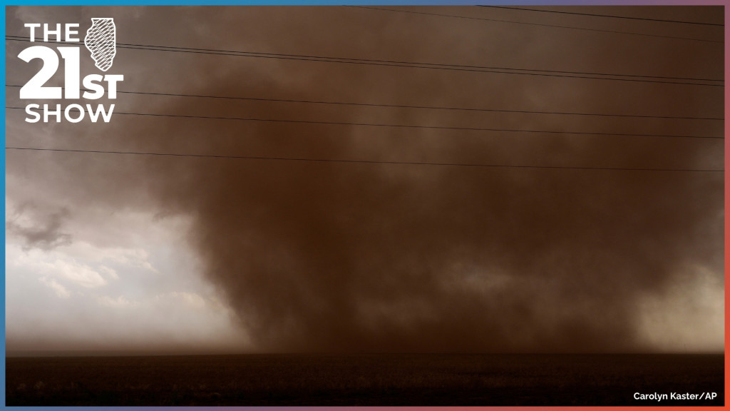
Transcript
// This is a machine generated transcript. Please report any transcription errors to will-help@illinois.edu.

[00:00:00]
Brian Mackey: It's The 21st Show. I'm Brian Mackey. And it's that time of year again when severe thunderstorms and tornado warnings become a normal part of life in Illinois. April showers and so on. But this year has been a strong one for tornadoes in particular. The Rockford area was recently hit with at least three, causing damage in the communities of Roscoe, Pecatonica and Lena, Illinois. And at least seven tornadoes touched McLean County last Friday, leaving a lot of brush to be cleaned up and causing damage to part of the Rivian plant. Now, when most people hear of a tornado warning, their instinct is to head for the safety of a basement or other shelter area. This is a correct instinct, by the way, but a few people hear about severe weather, cut against the crowd and head into the storm.

[00:00:56]
Andrew Pritchard: Hopefully it's not down behind me, but I think I'm doing myself a favor just blasting east out ahead of this storm right now 'cause I think it's wrapping up to do the thing. There it is, tornado.

[00:01:10]
Brian Mackey: That familiar voice is Andrew Pritchard, storm chasing on April 3rd. He's a meteorologist with Illinois Public Media and with Nutrient Ag Solutions. He tracked one of the more than 50 tornadoes that touched down in Illinois this year. Weather Realness, our sister program here at Illinois Public Media, spoke with him, as well as Jeff Frame, a professor in the Department of Climate, Meteorology and Atmospheric Sciences at the University of Illinois Urbana-Champaign. Frame takes students out to forecast and observe thunderstorms. They talked about what being a storm chaser is like and what they see when they're out in the field. Because this part of the program's on tape, no live calls, but you can let us know what you think. Our email address is talk@21stshow.org. OK, here's Weather Realness host Steve Nesbitt with Andrew Pritchard and Jeff Frame.

[00:02:02]
Steve Nesbitt: Let's start with you, Andrew. We just heard you during a chase on April 3rd. Where were you and what did you observe?

[00:02:08]
Andrew Pritchard: Well, back on April 3rd, I was in a familiar part of the area for folks in central Illinois, kind of in the Interstate 74 corridor between Peoria and Bloomington. We observed a brief tornado near the town of [Hopedale], but this was a long-lived supercell thunderstorm that caused severe weather, produced hail up to two inches in diameter as it tracked through that area, uh, before it dissipated just north of Bloomington during the late evening.

[00:02:32]
Steve Nesbitt: So let's listen to another tornado that you captured, Andrew. This was in Divernon, Illinois in Sangamon County down by Springfield in July of 2020.

[00:02:51]
Andrew Pritchard: Oh it's big, it's violent, violent tornado, violent tornado south of [Divernon].

[00:02:57]
Steve Nesbitt: Andrew, describe what you're seeing here, how fast you're going and what were you thinking?

[00:03:01]
Andrew Pritchard: Well, this was a situation that evolved really quickly. It was the day that I was out with my usual chase partner. His name is Colin, he's been my best friend for 20 years. We're very alike, so we agree a lot when we're making these very important storm chasing decisions. And this was a summertime day where we had a lot of instability. It was hot, it was muggy, and there was gonna be, you know, an unseasonable amount of wind shear with that setup as well. So we had a pretty good confidence we could observe a supercell, maybe a chance for a tornado. These storms erupted during the afternoon. They quickly became severe, but they kind of transitioned into a rainy mess. Uh, and we kind of thought, you know, maybe the day is gonna be a dud, but we drifted along with the storms and one particular storm just south of Springfield quickly, you know, cleared out, got its act back together and very rapidly produced a pretty significant tornado right in front of us. So this was a situation that went kind of from zero to 100 quickly. Now, I was not traveling 100 miles an hour down the road or anything like that. I do try to keep it within the speed limit here, but, you know, quickly trying to catch up to this thing because it appeared to be a very intense tornado that was going to be tracking toward the Interstate 55 corridor and some other population centers. So we wanted to make sure that we were reporting this to the National Weather Service so that they could get warnings out and alert folks that this situation was escalating and was at least dangerous at that time.

[00:04:18]
Steve Nesbitt: Yeah, so Jeff, what is the most impressive storm that you and your students have witnessed?

[00:04:22]
Jeff Frame: Yeah, so this one goes back to June 16th, 2014. That was on our second of two field courses we had that year. And it was a pretty looking to be a pretty high end day up in northeastern Nebraska. Um, and so after a little bit of uh driving around in circles, um, we saw a storm go up near the town of Norfolk. It looks like it should be pronounced Norfolk, but it is pronounced Norfolk. Uh, and we watched the storm and we came in from the back. We could see through the hook echo, uh, one tornado had crossed the road and began to dissipate off to our north. Um, and then we saw another tornado form a few miles in front of us. And then right next to that, another large tornado formed only a couple miles away, and both of these ended up being rated EF4 on the enhanced Fujita scale. Both caused pretty heavy damage near the town of Pilger in northeast Nebraska, and even more unfortunately, both of these did cause a few fatalities. Uh, one of these tornadoes would go on to dissipate. The other one continued on, and as we followed the storm northeast, it produced another large tornado, also rated EF4, and one of the older tornadoes looped around it at over over 100 miles an hour and merged in with the circulation. Um, so three instances of multiple EF4 tornadoes, I think is gonna be pretty, uh, pretty tough to beat.

[00:05:45]
Steve Nesbitt: Jeff, uh, what is the reason why scientists chase storms? Is it the thrill or is actual research or both?

[00:05:51]
Jeff Frame: Yeah, it's really actual research. Um, there are teams of mobile Doppler radars. Uh, there are some of those based in Boulder, Colorado. There are some, uh, Norman, Oklahoma. Texas Tech has some in Lubbock, Texas, and they take these radars out and get close to the storms, which means they're able to gather much more high resolution data in space and in time than the weather service radars are. The weather service radars aren't designed for that. And of course they are fixed, so they tend to be a lot farther away from the storms than if you drive the radar to them. And that lets us see how tornadoes form, how they persist, why some tornadoes last for an hour or longer, obviously able to cause a lot more damage if they do that, and able to sense, you know, the lowest 50 or 100 feet of the circulation right down near the ground where friction with the ground becomes a factor, and that's really where tornadoes cause their damage.

[00:06:48]
Brian Mackey: All right, we have to take a short break on the program, but when we come back, more from our Illinois Public Media sister show, Weather Realness, about what it's like to be a storm chaser. This is The 21st Show. Stay with us.

It's The 21st Show. I'm Brian Mackey. We're listening back to an episode of Weather Realness, a sister podcast produced by Illinois Public Media. In it, host Steve Nesbitt spoke about what being a storm chaser is like with Jeff Frame, a professor in the Department of Climate, Meteorology and Atmospheric Sciences at the University of Illinois Urbana-Champaign. He takes students out to observe storms in real time. Steve also spoke with Andrew Pritchard, meteorologist for Illinois Public Media and Nutrient Ag Solutions. Because this conversation is on tape, no calls, but uh you can always let us know what you thought. Our email address is talk@21stshow.org.

[00:08:21]
Steve Nesbitt: So Jeff, you teach a field course on storm observation and forecasting where you've led students to observe severe convective storms. What has your experience been like teaching students how to observe storms and has that inspired any students to storm chase?

[00:08:35]
Jeff Frame: Uh yeah, Steve, great question. Um, The students, uh, generally love the course. Um, my first time offering it in 2011, I was concerned about, you know, the amount of driving, which we'll get into later. Um, are they gonna be able to, you know, handle driving thousands and thousands of miles? And we pulled up to, to the storm out in Kansas after leaving Champaign-Urbana and the cumulus clouds are going up and developing into thunderstorms, and I think, you know, these might be the most photographed cumulus clouds in the history of Earth, how excited the students were, and they come back and they say, you know, I think I learned more in that two week period than I ever have in any kind of similar two week period in my life because we're basically just looking at the weather. Uh, we're not paying attention to the NBA Finals or Major League Baseball or a lot of the news even. Um, we're just out there, um, kind of focused on the weather. And yeah, some of our students, um, have gone out, uh, storm chasing. A couple of them, uh, saw the Kankakee tornado, um, earlier this year. Uh, class attendance that day, I'll admit was pretty bad. Um, but since I do teach every day, um, unlike Andrew, that does kind of limit my, uh, storm observing opportunities, um, kind of through, um, April and early May. Uh, because I do have commitments here on campus.

[00:10:00]
Steve Nesbitt: So clearly most people try to avoid these storms, but since you're entering a region that could be risky, what is your best way to maintain your own safety when you're out chasing?

[00:10:11]
Andrew Pritchard: Well, a great way to do that is to put brains together. So I do a fair amount of going out on my own, and, and sometimes I am alone when I'm observing some of these storms, but I, I try to be with somebody else, and that's a trusted friend, someone who's been doing this for a long time, so we can kind of have more eyes, a couple of brains, someone's driving, someone is navigating and making sure that we're looking ahead to the, the next move there. And that is kind of, that gets into the other part of that, which is just accumulating experience. So we always encourage people who are just beginning to go out with someone else so that, you know, they're helping you, you know, make some of these decisions that are very important to your safety and helping explain what you're seeing. And so you get to a point where, you know, someone like myself or Jeff is out in the field observing a storm, and I know that we don't need to look at radar to know what's going on all the time. It's a nice tool to have there, but you get to a point where you can look at the storm itself in front of you and know what's going on. You see the features, the areas to avoid, how things are evolving. You can kind of get the sense that, uh, this is going in a way I don't like. I'm not very comfortable, we should maybe move or Yeah, the storm looks like it has a lot of bite, but it's not actually all that severe. So it's, it's accumulating some experience, learning what you're doing out there, so that you can have situational awareness, always making sure you have an escape route, you're thinking ahead, and you're not just kind of out there, you know, as a cowboy having fun looking at a storm. You gotta know that that storm could cause damage, it can harm you, and you need to make sure you're treating it that way.

[00:11:37]
Jeff Frame: Right and one neat thing I've noticed out in the field is that if you're looking at a storm and you see it strengthening or weakening, that'll often lead what you see on radar by about 10 minutes because the radar only senses the rain falling out of the storm, but of course that rain the air first has to rise up in the storm, form the rain, and then the rain has to fall back down in order to be sensed by radar. Uh, so those visual cues can often be, uh, very helpful in anticipating, uh, what a storm might do in the near future.

[00:12:08]
Andrew Pritchard: I always kind of say this is a quick thought just to wrap that up, that, you know, a good meteorologist and storm chaser can look at the radar and tell you what that storm is doing. But a great meteorologist and storm chaser can look at the storm and tell you what the radar is going to do. Exactly what you said, Jeff, you can sometimes look at it and say, this storm is intensifying. And that doesn't actually show up on the radar until maybe 10 or 15 minutes later, and you've already made your decision to get into position for that because of that experience and that visual cue that you were able to pick up on.

[00:12:37]
Steve Nesbitt: So in another episode, Jeff, we talked about the role of artificial intelligence in weather forecasting. Do you see that ever playing a role in storm chasing? Will there be one day that models pinpoint exactly the track of a tornado and its strength or the path of a [derecho] or hailstorm?

[00:12:52]
Jeff Frame: Well, um, artificial intelligence is already um impacting at least severe storm forecasting. Uh, there are several different AI models and methods out there. Uh, one is run by Professor Russ Schumacher at Colorado State University, uh, where the models trained on weather patterns and also severe storm reports, um, because our, our data we use to train just the AI models can't resolve individual hailstones or tornadoes or anything like that. So saying based on these weather patterns and based on where storm reports have happened in the past, where do you expect severe weather to be based on this future weather pattern? Um, and there are a couple other um AI methods out there as well. Uh, but exactly pinpointing the path of a tornado that I think is a bit of a pipe dream at this point. Um, small scale features like thunderstorms and even smaller scale features like tornadoes offer a lot more limited predictability um than something like a hurricane or a blizzard or something like that. Um, now, [derecho], you know, as, as Andrew mentioned, uh, some of them are quite predictable. Uh, some of them, like the one in 2020 are very unpredictable. Um, so it's possible how we might be able to increase the predictability of those things a little bit.

[00:14:12]
Steve Nesbitt: In addition to covering the weather as it is happening, Andrew also has vlogs about the damage he sees after a violent weather system has moved through. Let's listen to his post from June 29, 2023. Some of you may remember that day, after a [derecho] moved through central Illinois.

[00:14:28]
Andrew Pritchard: This is unfortunate. Huge trees. This house got hit hard. There's another tree that fell on it. Gentleman over here said it just took seconds for all this to happen and these trees are kind of laying from southeast to northwest, which is what got my attention. What a mess.

[00:14:52]
Steve Nesbitt: Andrew, could you describe what you saw after you arrived in Farmer City that day nearly three years ago?

[00:14:58]
Andrew Pritchard: Absolutely, and I had picked out Farmer City as the place I was gonna ride this particular storm out. It was another one of these, uh, you know, [derecho] events, one of these big mean windbags, and, and it was another one of these that had damaging winds, but also little circulations and brief tornado potential. So, it looks like a corridor of very intense winds and maybe a spin up tornado was gonna move through the Farmer City area. So I got in there just as the storm was beginning to uh move through town, there was a period of very intense winds. I will say that it was different from the August 10th, 2020 event, whereas that 2020 event went on forever. It felt like it was like 20 or 30 minutes of severe winds that just felt relentless. And this June 29, 2023 event was very intense, but the strongest winds were kind of in a three to four minute time frame. So it was very in and then out very quickly. And so, I rode the storm out in the downtown area, which, uh, you know, took some minor damage, but it was as I started moving through the north and east parts of town, closer to, uh, where I believe it's Highway 54 runs through town and then meets Interstate 74, and there were a lot of trees down, and unfortunately some of them down on homes or on cars, uh, you know, sometimes bringing down power lines along with them. So, there appeared to be a corridor of very intense winds where either a spin up tornado or I think more likely what we call a microburst or one of these burst swaths went through a very narrow path of intense winds. But, you know, sometimes we talk about a big mean tornado going through the open fields and causing no damage. Well, we can also sometimes get just the unfortunate overlap of a very narrow corridor of intense winds going right through, you know, a small community here in central Illinois. So Farmer City and other communities took a lot of wind damage that day from that, uh, storm system.

[00:16:42]
Steve Nesbitt: We talked about AI earlier, Jeff. Are there any future changes in storm chasing that you might anticipate?

[00:16:47]
Jeff Frame: Um, well, storm chasing has changed a lot, um, over the years. Um, you know, back into the 1990s and early 2000s, uh, before mobile internet. Um, what chasers would do is they would look at weather data in the morning and then they would drive out somewhere and they would have no access to live data on their car phones as they were called in those days. Um, so they might use a pay phone to call somebody, you know, at home in an office, you know, looking at data called a nowcaster. Occasionally they would stop by a public library to use the internet there in a publicly accessible place, and sometimes they descend on National Weather Service offices, but they really wouldn't like that because they're kind of busy with a potential severe weather day and they don't want to have to deal with a horde of storm chasers, most of whom they don't know, begging for data. Um, so it has become a lot more popular with the first Twister movie, the Storm Chaser show on the Discovery Channel, and then as Andrew mentioned, the advent of streaming on YouTube makes it a lot more accessible to a lot of people, and also the Twister sequel that came out in 2024. Uh, so we're seeing a lot more people chasing. Um, I think it will likely continue to get popular, more popular in the future. Um, I think our models will continue to get better as we make investments in science and things like that. But, you know, it's a, it's a tough call to say, you know, how, how things might change. Um, last year, um, some, I think, uh, misled Oklahoma legislators promoted a bill in their, in their House and Senate down there to look at a storm chasing license, and a lot of people did fight that and ended up not passing. I think there were a couple of well known storm chasers with a TV station down there who were behind that, but ultimately that failed. And and the thing is to stop things like that from happening, chasers do need to chase safely, chase courteously, obey the laws, things like speed limits, stop signs, red lights, those basic laws of the road to keep not only other chasers, but everybody else safe, including emergency vehicles as well.

[00:18:58]
Steve Nesbitt: So Andrew, Illinois has had an active tornado season thus far. Uh, does this take a toll on you in terms of always being out? Do you get tired? And is there any indication that our active severe season is going to fall off or shift to other parts of the country?

[00:19:12]
Andrew Pritchard: It's certainly been a busy start to the year, and we've had a series of years with high tornado counts here in the state. So the Midwest has been pretty active a few years in a row here, and kind of the the truth of it is every spring is going to be a little bit different, and even two really active springs are going to be different as well, kind of in where they place these active corridors and, you know, when they're active. So, it has been active here, going back to the end of February through March, and then we've had another burst here in the first half of April, and there are certainly some indications as we look out into the forecast for May, June, and July that there could continue to be stormy stretches from the plains into the Midwest. So, I do kind of, you know, hypothesize or speculate here that we're probably gonna continue to see a pretty active season in the Midwest, probably another above average season, but within all of that, there will be quiet stretches. So it does look like this current active stretch is going to be coming to an end. It looks like maybe the opportunity for some cooler weather, quieter at times here across the Great Lakes, but there's also some pretty big signals that even in the next seven to 10 days that another big push of jet stream momentum could come in across the southwestern U.S., maybe focused on the southern plains, parts of the Midwest. So, kind of a mixed bag answer there. I think that yes, we're looking at probably a continued active pattern here in the Midwest, including in the state of Illinois, but there will be some quiet stretches here, uh, as well. It will not be relentless through the rest of the spring on into the summer. We will get our breaks.

[00:20:38]
Steve Nesbitt: I guess the good news is that drought is waning in central Illinois, so there's always good with the bad [regarding] severe weather.

[00:20:45]
Andrew Pritchard: Absolutely, yeah, my sump pump in my basement has gone from a dry, dusty, uh, pit and now is full and and running and we've had water coming into the basement. We're just living that active, stormy lifestyle here in the Midwest.

[00:20:58]
Steve Nesbitt: So we've been talking about chasing storms with meteorologist Andrew Pritchard. He's a meteorologist at Nutrient Ag Solutions in Illinois Public Media as well. You can look up all his tornado and storm chasing videos on YouTube. Search for Sky Drama, all one word. Also, thanks to Jeff Frame, professor in the Department of Climate, Meteorology and Atmospheric Sciences at the University of Illinois. Thank you both for joining us today.

[00:21:20]
Andrew Pritchard: Thanks so much for the invitation.

[00:21:23]
Brian Mackey: That's all the time we have on our show today. Coming up Monday, three white men have been arrested following a shooting at a lake in Paris, Illinois that involved Danville Alderman Jaleel Jones, a black man, and two of his friends. We'll talk about what happened and the implications for that situation. Plus, many students go to college hoping to become filmmakers, but not many get firsthand experience with professional filmmaking that early in their careers. We'll talk with a college sophomore whose short film documentary on a small business in the Quad Cities is now available to stream on Roku.

We'd love to hear what you think about what we've been talking about, whether it's today's program or anything in the past. If you like it, if you didn't like it, if you think we got something factually wrong, or maybe you like something, we'd love to hear about it. You can leave us a voicemail anytime, day or night. The number is 217-300-2121. That's 217-300-2121. And you can find that number, our email address, and every other way to contact us on our website, 21stshow.org.

The 21st Show is produced by Christine Hatfield and Jose Zepeda. Our digital producer is Kulsoom Khan. Technical direction and engineering comes from Jason Croft and Steve Morck. Reginald Hardwick is our news director. The 21st Show is a production of Illinois Public Media. I'm Brian Mackey. Thanks for listening. We'll talk with you again on Monday.
Transcript Assistance
Illinois Public Media may use AI assistance for transcript generation and/or formatting. Transcripts that have not yet been reviewed for accuracy will be labeled.
To report a transcription error, or to request transcription of archival material, please contact will-help@illinois.edu.
